Whidbey Island Weather: A Tale of Microclimates and Rain Shadows
Imagine living on an island where it’s pouring rain in your yard, but just a few miles away, the sun is shining bright. That’s Whidbey Island weather in a nutshell—a patchwork of microclimates that keeps life here as interesting as it is beautiful.
People often fall in love with the evergreen charm of the Pacific Northwest, but the gray skies can be a challenge for those of us who thrive on sunshine. As someone who considers herself “solar-powered,” I’ve learned just how much Whidbey’s unique weather quirks can shape daily life.
The Magic and Madness of Whidbey’s Microclimates
When my husband and I bought our first home near Goss Lake in Langley, we were enchanted by the trees and tranquil setting. What we didn’t realize was how much those trees—and the property’s east-facing orientation—would affect our lives. Half the year, our house barely saw a sliver of direct sunlight. And in winter? It felt like our front yard got hit with more ice and snow than anywhere else on the island.
Meanwhile, my parents, who lived near Penn Cove in Coupeville, would be enjoying sunny skies while it poured rain at our house just 30 miles away. This dramatic contrast is one of Whidbey Island’s most fascinating (and occasionally frustrating) features.
Whidbey is a smorgasbord of microclimates, thanks to factors like:
Tree cover and shade
Wind tunnels in certain areas
Elevation changes
Open spaces vs. forested areas
Maritime influences from the surrounding waters
One of the biggest variables is shown in the precipitation map.
The darker the area, the wetter it is. The driest area of the island is in Central Whidbey and Coupeville.
The Rain Shadow: Central Whidbey’s Secret Weapon
One of the biggest weather variables on Whidbey comes from the Olympic Mountains. These towering peaks create a “rain shadow” effect, where weather systems are pushed around the mountains, leaving certain areas—like central Whidbey—drier and sunnier. The next time a storm blows through, check out a doppler radar map—you’ll likely see a clear “hole” in the storm right over central Whidbey, like the calm eddy behind a big boulder in a rushing river.
Here’s how it works:
When storms roll in from the Pacific Ocean, they hit the Olympic Mountains and are forced upward. As the air rises, it cools and condenses, dumping most of its moisture on the western slopes. By the time the air reaches Whidbey, it’s significantly drier, creating a pocket of sunshine over Coupeville and the surrounding areas.
Resources for Weather-Watchers on Whidbey
Living on Whidbey, you’ll find yourself caring about the weather more and more. To stay ahead of the curve, I recommend following Jonathan Pully, a local weather enthusiast whose predictions on the Facebook group “Whidbey Island Weather” are often more accurate and detailed than major weather apps. Pair his insights with the Wunderground app, my personal favorite for tracking local forecasts.
When the Wind Blows: Power Outages on Whidbey
One of the weather patterns we keep a close eye on here is the wind. Windy storms aren’t just blustery inconveniences—they’re the leading cause of power outages across the island. Thankfully, Puget Sound Energy (PSE) has made major improvements over the years, both in preventing outages and responding quickly when they do happen. The days of being without power for weeks are mostly behind us, but let’s be honest—it doesn’t quite feel like winter on Whidbey without at least one good, old-fashioned outage.
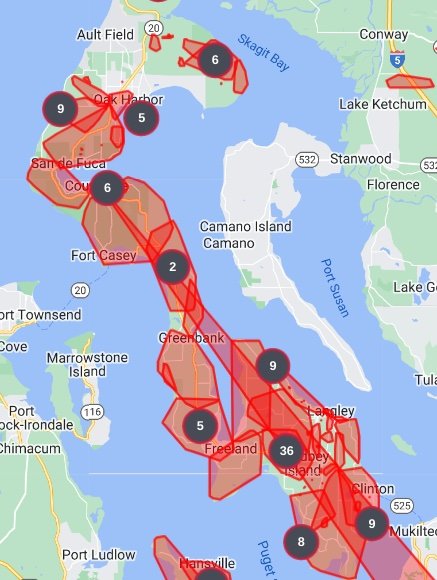
PSE’s handy power outage map is also available as an app, which can send you real-time text updates with estimated restoration times. It’s a great tool—assuming you have cell reception to actually receive those texts. But that’s a whole other topic for another blog post...
PSE Power Outage Map, for visual drama ;)
Weather-Driven Whidbey Adventures
Weather isn’t just something to track here—it shapes how we enjoy the island. One of my favorite weather-related activities is taking advantage of super low tides. When the stars (and weather) align—think a -2 or lower tide, light winds, and no rain—you’ll find me at Joseph Whidbey State Park with my pup, exploring the wide expanse of beach. There’s nothing like seeing your dog frolicking in the sand, surrounded by stunning views of Saratoga Passage and the Olympic Mountains.
It’s incredible how much compact sand is uncovered at low tide at Joseph Whidbey State Park. Perfect for walking barefoot in the summer months.
Why Whidbey’s Weather Matters
Whidbey’s quirky weather is more than just a conversation starter—it’s an integral part of life here. Whether you’re choosing the perfect spot for your dream home or planning your next outdoor adventure, understanding the island’s microclimates can make all the difference.
What’s your favorite Whidbey Island weather quirk? I’d love to hear your stories! Drop a comment below or reach out if you’re ready to find your sunny (or shady) spot on Whidbey Island.
Resources to learn more:
If you want an excellent tide tracking app I recommend the Tide Alert App.
For a more scientific view of weather in this region check out this excellent Story Map called “Climate of the Salish Sea BioRegion” https://storymaps.arcgis.com/stories/22a63e2a35214bc1bdcc118d518938aa


